South Korean Natural Landscapes: AREA AND LANDFORMS
The 38th parallel had some precedent as a partition, and it did have some geographic features that supported it as a dividing line for 55 percent (north) and 45 percent (south) of the peninsula. Mineral wealth was more abun-dant in the north, and agricultural land was much better in the south. And, most logically, what came to be North Korea shared a short border with the U.S.S.R. and its newally, the People’s Republic of China. This 1948 division has been the de facto border between the two Koreas for more than half a century.
South Korea has the Yellow Sea and the East China Sea on the west and south. On the eastern side lies the Sea of Japan. There are some 3,000 islands that are seen as part of the two countries of the peninsula, although most of them are uninhabited. The largest of all the Korean islands is Cheju Island, an integral part of South Korea. It lies to the south, southwest of South Korea, and has an area of 713 square miles (1,846 square kilometers), and is a province. The island has a rather unique history reflecting relative independence from the rest of the peninsula.
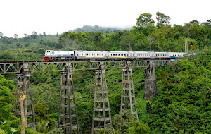
The whole landscape of South Korea is characterized by very hilly topography, made smooth only where river valleys are cut from the Taebaek Mountains on the eastern edge of the peninsula and on the flanks of the Sobaek Mountains as they run diagonally toward the southwest border of South Korea. The Taebaek Mountains run generally from north to south, while the Sobaek are southwest to northeast in their trend. The 819 miles (1,319 kilometers) of South Korea’s coastline are relatively smooth on the eastern side of the country and highly indented on the embayed western side. This has created a landscape that is characterized by small fishing villages that have long taken advantage of the resources of the Yellow Sea and its marine life. The overall extent of South Korea is approximately 300 miles (480 kilometers) from north to south and 185 miles (298 kilometers) from east to west.

South Korea is the southern part of the Korean Peninsula, which juts off from the eastern edge of Asia. South Korea has the Yellow Sea on the west, the East China Sea on the south, and the Sea of Japan on the east. It has a very hilly topography, made smooth only where river valleys are cut from the mountains. The coastal plains and the south-facing river valleys provide the major areas for agriculture and human settlement in the country.
The coastal plains and the south-facing river valleys provide the major agricultural and settled landscapes of the country. One of the distinctive landscape features of his country is the high tidal range near Inchon in the Ktanghwa Bay region on the western side of the peninsula. The tidal range may amount to as much as 30 feet (9 meters) along this part of the west coast while corresponding latitudes on the east coast of the peninsula will seldom have a tidal range of more than three feet (a meter). There are no natural channels that enable the South Koreans to capture the power of this daily flux in water level, but it has forced a creative wharfing and village landscape design to be able to accommodate such a daily change in water levels.
Realize that overall the Korean Peninsula is a land of mountains and substantial hill lands. While none of then peaks or the mountain systems take on the scale of similar topography in either Japan or China, there is a totality to the presence of mountains in both South and North Korea that, at least from the air, creates an impression that geographer George Cressey described as “[a land that] resembles a sea in a heavy gale.” He goes on to point out, “High mountains are uncommon; it is [the mountains] profusion here that is impressive. No plain is so extensive that the encircling mountains cannot be seen on a fair day.”
The broad regions of North and South Korea are separated in part by a valley that slices from the northeast to the southwest. This serves as a strong visual divide between the two sections of the peninsula as they lie segmented into South Korea and North Korea. The regional system that follows can be used to delineate distinct landscapes and land use on the entire peninsula.source: Salter, Christopher L. South Korea


1 komentar:
wusss, background e sangar (unyu unyu :p)
Posting Komentar